Why Urban Tree Canopies Matter for Pittsburgh’s Historic Neighborhood Microclimates
Why Pittsburgh Microclimates Depend on Urban Canopy Cover
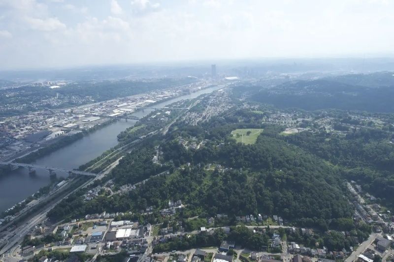
Pittsburgh”s hills, river corridors, steep ravines, and compact historic neighborhoods create a city of highly localized climates. A shaded street in a mature residential district can feel markedly different from a nearby block lined with asphalt, brick, rooftops, and parking lots. Ridges may receive stronger afternoon sun, while deep valleys can hold heat and polluted air after dark, especially when calm weather limits ventilation. The result is not one Pittsburgh heat island, but a patchwork of neighborhood microclimates shaped by elevation, slope, building form, pavement, and vegetation.
Mature deciduous street trees are among the most effective tools for moderating those conditions. Their leaves intercept solar radiation, shade sidewalks and walls, and release water through evapotranspiration. They also improve stormwater management, air quality, habitat, and the everyday comfort of walking through historic districts. Research and local mapping increasingly show how canopy loss follows older patterns of investment and disinvestment. At the same time, community planting programs are demonstrating that carefully targeted native trees can restore cooling where it is needed most.
Reading the Ridges and Hollows Through Thermal Remote Sensing
Land surface temperature data provide a useful first view of Pittsburgh”s uneven heat exposure. Thermal satellite imagery does not measure exactly what a person feels at street level, and it should not be confused with an official air-temperature reading. It does, however, reveal how intensely roofs, pavement, bare soil, vegetation, and water absorb and release heat. When those observations are combined with elevation models, tree inventories, building footprints, and impervious-surface maps, planners can identify persistent hot spots rather than relying only on citywide averages.
Pittsburgh”s topography makes this analysis especially valuable. A south-facing slope may receive prolonged solar exposure, while a narrow valley can collect heat radiated from surrounding pavement and masonry. Asphalt corridors often remain warm well into the evening, whereas blocks beneath a continuous tree canopy can show substantially cooler surface conditions. High-resolution land-cover data also help distinguish a large forest patch from scattered street trees, a distinction that matters for shade continuity, pedestrian comfort, and access to cooling.
The US EPA”s meter-scale land-cover guidance describes a one-square-meter-per-pixel dataset that classifies urban landscapes as impervious surface, tree, grass-herbaceous, shrub, soil-barren, water, wetland, or agriculture. Its reported mean accuracy across participating communities was 88 percent. For Pittsburgh, this kind of granular information can support practical decisions along sidewalks and asphalt corridors, including where a tree pit could close a gap in shade, where roots need protection, and where planting should be paired with stormwater infrastructure.
- Topography: slope orientation, elevation, and valley form influence sunlight, airflow, and heat retention.
- Surface materials: dark roofs, pavement, and parking lots absorb more solar energy than shaded soil or planted areas.
- Canopy continuity: connected crowns often provide more useful pedestrian shade than isolated trees separated by multiple exposed blocks.
- Resolution: meter-scale mapping can reveal differences that disappear in broad neighborhood averages.
How Historic Zoning Created Contemporary Urban Heat Pockets
Heat exposure is also a record of policy. Twentieth-century redlining and related patterns of housing discrimination influenced where public investment, street improvements, parks, and private development accumulated. In Pittsburgh, parts of Garfield, the Hill District, the North Side, and the South Side are among the areas identified as historically redlined and now associated with lower vegetation levels and more heat-absorbing surfaces. The policy itself was not a tree-planting rule, but its effects shaped the physical conditions in which trees were planted, maintained, removed, or replaced.
Local reporting on a Carnegie Mellon University study has described temperature differences approaching five degrees between some formerly redlined neighborhoods and cooler parts of the city. Some locations have tree cover as low as 5 percent, while a 10 percent increase in green coverage has been associated with potential temperature reductions of 3.6 degrees. These figures should be interpreted as neighborhood-scale findings rather than a guarantee for every individual block, but they clearly illustrate why canopy is an equity issue. Residents who have fewer nearby trees may also face higher cooling costs, less comfortable walking routes, and greater exposure during extreme heat.
Broader peer-reviewed research supports the connection between historical redlining, contemporary heat, and health risk. A study of 11 Texas cities found that a greater proportion of historically redlined land was associated with higher land surface temperatures and, after adjustment for social vulnerability, elevated rates of heat-related emergency department visits. Pittsburgh has different geography and climate, so the study should not be transferred mechanically. Its central lesson remains relevant: historic investment decisions can leave durable environmental conditions that require explicitly equitable planning responses.
| Neighborhood condition | Likely microclimate effect | Planning response |
|---|---|---|
| Continuous mature canopy | Lower surface temperatures and more comfortable sidewalks | Protect roots, prune carefully, and replace aging trees before gaps widen |
| Large expanses of asphalt | Strong daytime heat absorption and evening heat release | Combine shade trees with permeable surfaces and stormwater design |
| Steep, exposed slopes | Greater solar exposure and difficult soil conditions | Use slope-appropriate species and protect soil from erosion |
| Formerly disinvested blocks | Reduced canopy, limited shade access, and greater heat burden | Prioritize tree equity, maintenance funding, and resident-led planning |
Quantifying Shading and Evapotranspiration Across Neighborhood Streets
Urban trees cool streets through two related mechanisms. First, their crowns block incoming solar radiation before it reaches pavement, vehicles, walls, and pedestrians. This is the most immediate benefit on a summer afternoon. A broad deciduous canopy can also shade upper stories and reduce the amount of heat entering homes, although the actual benefit depends on tree placement, building orientation, window exposure, and ventilation.
Second, trees cool the surrounding air through evapotranspiration. Water moves from the soil through the tree and exits through tiny openings in the leaves. That phase change consumes energy, reducing heat near the foliage. The effect is strongest when trees have adequate soil moisture, healthy roots, and enough growing space. A stressed tree may still provide shade, but drought, compacted soil, road salt, pests, and root damage can reduce its long-term cooling performance.
New modeling approaches are combining satellite-derived land surface temperatures with vegetation, emissivity, building, road, and other urban data. A physics-informed neural-network preprint tested in Bologna and Washington, D.C., reported average cooling from modeled green-infrastructure scenarios and larger localized reductions near targeted interventions. Because that work is a preprint and has not undergone peer review, its numerical results should be treated as promising rather than definitive for Pittsburgh. The broader direction is important: models are moving toward identifying which interventions are most useful on particular blocks, rather than treating every tree planting as equally effective.
Recent empirical work on urban thermal mitigation likewise points toward the direct thermodynamic value of leafy infrastructure. The linked Nature research publication should be read in full before applying its methods or findings to Pittsburgh, particularly because local slope, species, soil moisture, and weather patterns differ. For city decision-makers, the practical implication is to measure both canopy extent and canopy performance, including shade at key hours, tree health, soil conditions, and the temperature of adjacent walking routes.
- Map existing shade at sidewalks, bus stops, school routes, senior housing, and commercial corridors.
- Prioritize locations where a small number of strategically placed trees could connect separate canopy patches.
- Pair plantings with adequate soil volume, root protection, watering plans, and permeable surfaces.
- Monitor tree survival and crown growth, not simply the number of trees installed.
Community Forestry Restoring Balance in Valley Neighborhoods
Community forestry is most effective when planting is treated as long-term neighborhood infrastructure rather than a one-day beautification project. Tree Pittsburgh, the Western Pennsylvania Conservancy, municipal leaders, community organizations, and residents have increasingly connected planting decisions to heat risk, sidewalk conditions, stormwater, and local priorities. Pittsburgh”s data-driven initiative launched in 2023 with Resilient Cities Catalyst, Tree Pittsburgh, the Western Pennsylvania Conservancy, and UrbanKind Institute used climate-risk information and ecosystem-benefit calculations to direct investment toward neighborhoods facing greater exposure.
The program coordinated trees with public works projects so that plantings could receive sufficient growing space while supporting air-quality improvements, shade, traffic calming, and stormwater management. Over two years, 50 trees were planted in Beltzhoover and 47 in Hazelwood, with 21 additional trees planned for Homewood along Hamilton Avenue. The city has also described plans for a Tree Equity Working Group focused on heat-risk communities, particularly communities of color. These efforts matter because a newly planted tree cannot immediately replace the cooling service of a mature canopy. Protection, watering, and maintenance must accompany installation.
Species selection requires a balance between native ecological value and urban durability. Trees must tolerate compacted or disturbed soil, limited rooting space, salt exposure, drought, pests, and the temperature extremes expected to intensify with climate change. Native species can support local wildlife and strengthen regional ecological connections, but no single species should dominate an entire streetscape. Diversity reduces the chance that one insect or disease will remove a large share of the canopy at once. Research on urban forests and non-native forest insects also reinforces the need for careful inspection, responsible sourcing, and ongoing monitoring, even though the available source summary does not establish a specific Pittsburgh pest forecast.
- Inventory what already exists. Identify mature trees, healthy forest patches, vacant planting sites, overhead utilities, sidewalk constraints, and locations where construction could damage roots.
- Match species to conditions. Consider slope stability, soil volume, salt exposure, mature crown size, utility conflicts, and expected drought stress before selecting a tree.
- Protect the root zone. Avoid unnecessary excavation, soil compaction, contaminated fill, and repeated vehicle loading around established trees.
- Plan the first three years. Watering, mulch management, structural pruning, and early pest detection often determine whether a young tree survives.
- Build local ownership. Neighborhood associations and property owners can adopt trees, report damage, coordinate watering, and participate in canopy monitoring with civic and nonprofit partners.
Existing canopy deserves special attention during redevelopment. Healthy trees can be lost quickly to grading, utility work, construction traffic, or storm damage, while replacement trees may take decades to provide comparable shade. Developers can inventory trees before design begins, preserve critical root areas, maintain soil aeration, add native plantings, and incorporate rain gardens where appropriate. For homeowners and neighborhood groups, simple actions such as avoiding contaminated water, using proper pruning methods, keeping mulch away from trunks, and preventing soil compaction can extend the life of valuable trees.
Cultivating Cooler and More Resilient Pittsburgh Communities
Pittsburgh”s heat patterns emerge from the interaction of physical geography and social history. Ridges and valleys shape sun exposure and airflow, while pavement and dense construction store heat. Historic disinvestment has left some neighborhoods with fewer trees and less access to cooling green space, making canopy restoration a matter of public health and fairness as well as environmental design. Thermal mapping can identify the most exposed blocks, but residents should help determine where shade is most urgently needed and which planting plans fit neighborhood character.
The most durable strategy combines preservation with targeted restoration. Residents can join local planting and stewardship programs, report damaged or declining trees, support tree inventories, and ask for canopy protection during sidewalk, road, and building projects. Planners and preservationists can use high-resolution land-cover data to guide investment without erasing the distinctive streetscapes of Pittsburgh”s historic communities. With consistent maintenance, diverse native plantings, and community-led monitoring, today”s targeted trees can become tomorrow”s cooling infrastructure, protecting comfort, health, and neighborhood resilience for generations.